
10000 Kilometer Rain Cloud Spotted From India to South Korea as Strong Monsoon Conditions Build Across Asia

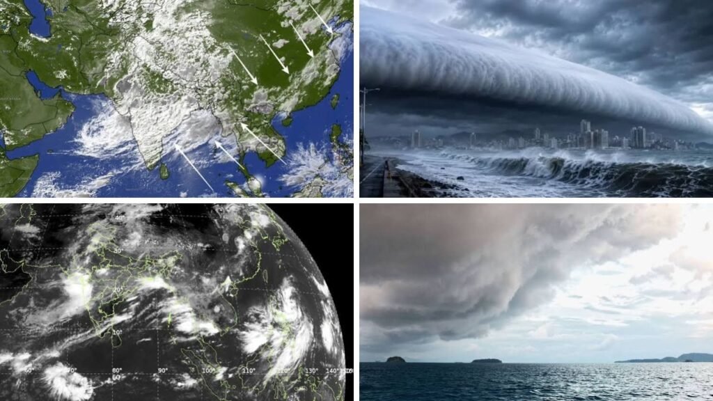
A satellite image showing a wide swath of rain-producing clouds stretching from northern India to South Korea has revealed the extent of Asia’s active monsoon circulation. The reports say the feature extends between 7,000 to 10,000 kilometres across the Himalayas, China and east Asia. It’s not one cloud, but rather a large corridor of related storm systems that develop under good atmospheric conditions.
 Telangana Rain Update as Heavy Showers Bring Cooler Weather and IMD Issues Fresh Rainfall Warning
Asian Monsoon Cloud Band Connects Several Weather Systems
This Asian monsoon cloud band is an expression of the interaction of moisture laden winds and regional pressure systems over a vast area. Warm, humid air is being drawn in from the Arabian Sea, Bay of Bengal and larger Indian Ocean. When this air encounters low-pressure areas and zones of convergence in the atmosphere, it rises, cools and creates heavy rain clouds. While there are clusters of showers and thunderstorms, the pattern can appear almost continuous on satellite images.

What’s That Big Rain Cloud?
This feature is better described as an ordered rain belt, rather than as one giant cloud. Satellite images reveal thick cloud cover over central, northern and eastern India and across the Himalayan area and farther into East Asia. This vast structure demonstrates how weather systems in different nations can become connected via large-scale wind circulation. Thus conditions over India can lead to severe rain over China, Korean Peninsula and neighbouring locations.
What has made it form?
Several things have happened jointly. The south-west monsoon trough over India continued to be active and moisture continued to surge inwards from the surrounding oceans. That humid air has been lifted by low pressure systems and cyclonic circulations which has contributed to foster widespread cloud growth. Convergence happens when winds blow towards the same place, driving air higher and assisting in condensation. This can lead to large areas of dense cloud cover, with rain and thunderstorms.

Recent rainfall estimates show that India received roughly 170% to 180% of its usual daily monsoon rainfall for the two-day period. The India Meteorological Department also warned of “exceptionally heavy” rain in Gujarat and “extremely heavy” rain in parts of Maharashtra, underscoring the strength of the spell.
Does It Mean a Bumper Monsoon?
The graphic shows a strong active phase but doesn’t assure above normal rainfall for the full season. How long these systems stay, where the heaviest rain is and if dry breaks return, all plays into seasonal performance. The World Meteorological Organization’s prediction for 2026 had earlier pointed to below-normal seasonal rainfall across much of South Asia and that’s why one rainy episode can’t be seen as the end outcome.
But the active phase for a long period could increase rainfall totals over places that got rain in fits and starts. It can recharge reservoirs, groundwater and rain-dependent farms. Meanwhile, heavy rain poses threats to communities, including urban flooding, flash floods, river and landslide flooding.
Asia Faces Heavy Rain Risks
The wider pattern is already impacting vulnerable regions. Torrential rains recently caused floods and landslides in regions of Vietnam, South China and South Korea. A weather station in Paju, north of Seoul, recorded 192.5mm of rain. These totals demonstrate why people need to pay attention to local warnings, rather than simply look at the cloud band as a striking satellite feature.
How scientists observe the cloud band
Meteorologists watch these systems with satellites, radar, rain gauges and forecast models to see where and how strong they are. The information is used for rainfall forecasting, and helps organisations give warnings for floods and landslides. This is not simply because it is 10,000 kilometres long, but because it shows just how intimately linked Asia’s monsoon weather can be.
Sources
- India Today: Satellite imagery shows a monsoon convergence zone of 7,000 to 10,000 km from northern India to South Korea.
- Moneycontrol: The visible feature is not a single continuous cloud but a connected zone of rain-bearing systems that is being sustained by the monsoon circulation.
- IMD: also issued warnings of very heavy rainfall in Gujarat and extremely heavy rains in areas of Maharashtra.
- World Meteorological Organisation: The seasonal prognosis for 2026 expected below-normal monsoon rainfall across much of South Asia, while regional variances were probable.
- The Guardian: Torrential rain hit Vietnam, southern China and South Korea, with Paju registering 192.5 millimetres of rainfall.
