
Severe Weather Threat Expands Across the Central US for Several Days

What’s Behind the Severe Weather Threat?
This is bringing in warmer, more humid air into stronger winds and storm systems in the central part of the country, increasing the threat for severe weather. Such a set-up can lead to rapid thunderstorm development, especially during the afternoon and evening hours when instability is usually strongest.

- Warm, moist air is giving storms more energy.
- Storms can be caused by cold fronts and low-pressure systems.
- Strong winds aloft can organise the severe thunderstorms.
- Repeated storm rounds could raise flooding concerns.
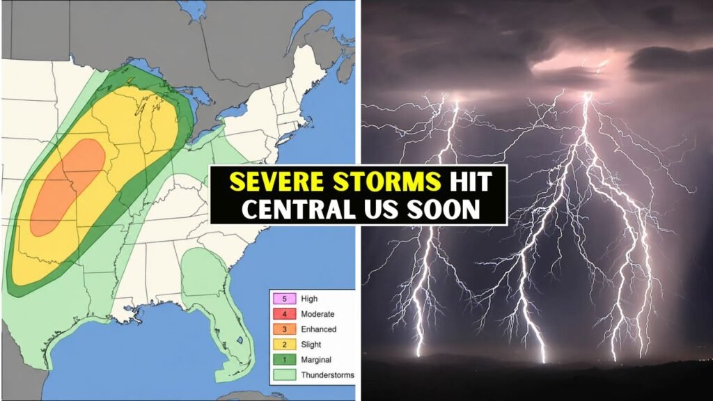
Where are the riskiest spots?
While the biggest concern can change on a daily basis, parts of the Plains, Midwest and Central US are still in the crosshairs. Depending on the exact storm track and timing, strong storms could develop in Texas, Oklahoma, Kansas, Nebraska, Iowa, Missouri and nearby areas.

- Southern Plains could get hail, heavy rain.
- Damaging wind gusts possible in Central Plains.
- Midwest regions could see strong storms during the evening.
- Cities need to look out for flash floods.
What are the most probable Hazards?
Damaging straight-line winds, large hail, frequent lightning, heavy downpours and isolated tornadoes are the primary threats. Not all communities will be affected by severe weather, but strong storms could cause damage to property, travel delays, power outages and dangerous road conditions in a short period of time.

- Damaging winds could bring down trees and power lines.
- Big hail can damage vehicles, roofs and crops.
- Heavy rain could cause flash floods.
- Possible isolated tornadoes.
- All storms will still be a threat of lightning.
At What Time Do Storms Reach Their Peak?
In general, the late afternoon, evening and overnight hours are the most common for severe storms (though this can vary by location). In some areas there could be more than one round of storms over a few days so it is important to check back for updated forecasts rather than rely on one weather outlook.
Why is flash flooding important?
Flash flooding could happen with slow-moving storms or storms that hit the same areas several times. Heavy rain can cause streets, small streams and shallow crossings to become flooded for a short period. Night-time flooding is especially dangerous because the depth of the water is more difficult to judge.
- Do not drive on flooded roads.
- If water rises quickly, get to higher ground.
- Charge your phones to get emergency alerts.
- Monitor low lying and poor drainage areas closely.
What Should Residents Do Now?
Storms are coming; those in the danger zone should prepare. A good warning system, emergency supplies and a safe shelter plan will reduce danger. “Families need to know where to go if there is a warning, especially during night-time storms when people could be sleeping.
What to Remember for Travellers?
Travellers in the Central US should expect delays, reduced visibility, flooded roads, and sudden weather changes. Highways are good places to run into severe storms that can develop quickly, and it can be dangerous to stay on the road through heavy rain, hail or high winds without first checking conditions.
- Check radar before driving long distances.
- Delay trips when major warnings are in place.
- Do not take cover under bridges during tornado threats.
- Have an emergency kit in the vehicle.
How long can the severe pattern last?
The extreme weather pattern could last for days as storm systems move through the region with unstable air in place. Risk areas can shift from day to day, so residents should stay tuned to their local community for National Weather Service updates, watches and warnings.
What’s The Bottom Line?
The threat for dangerous severe weather in the Central US is a multi-day event, not a one-time event. Damaging winds, large hail, heavy rain, flash flooding and isolated tornadoes are possible. Staying weather aware, reviewing safety plans and acting quickly when warnings are issued can save lives and property.