
New Satellite Images Show India Covered by Thick Clouds as Monsoon Returns at Full Strength

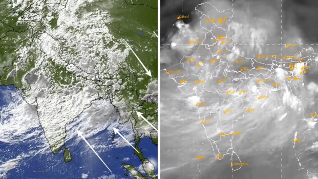
Recent satellite images show India enshrouded in heavy clouds suggesting the pace of the south-west monsoon has increased after a brief dry spell. The weather satellite images over the last few days have shown thick bands of cloud over much of the country, suggesting that rain activity has again become active. The revival is likely to bring widespread showers to many states improving seasonal rainfall conditions and is likely to allay concerns over weakening monsoon activity.

Why are thick clouds suddenly covering India?
Latest satellite observations show monsoon cloud cover over nearly half to two-thirds of India’s land mass. The change is considerable as only a few days ago large parts of central, western and northwestern India had relatively clear skies during a temporary lull in rainfall.

Meteorologists said the monsoon was strengthened after new weather systems formed over the Bay of Bengal, allowing moisture-laden winds from the Arabian Sea and the Bay of Bengal to sweep over the country. This has helped re-establish the monsoon circulation and strengthen cloud build up over many areas.

Why monsoon broke early?
This temporary slowdown was associated with changes in large scale atmospheric conditions.

Weather experts said a strong tropical cyclone over the western Pacific had pulled moisture away from the Indian region affecting the normal monsoon circulation. As a consequence, the monsoon trough weakened, resulting in less cloud formation and below-normal rainfall in several states even after the monsoon had covered the country.
Where is the rain expected?
The monsoon has got active again and northern, central, eastern and parts of western India are likely to witness more rain. Satellite images have revealed a thick blanket of cloud over the Indo-Gangetic plains, eastern India and some northeastern states, even as active weather systems continue to brew up over the neighbouring seas.
The return of the rain could provide some respite from the heat and add to soil moisture, which would be helpful for farming in the crucial Kharif cropping season. But areas affected by long spells of heavy rainfall could also be at risk of waterlogging, localised flooding and traffic problems.
Satellite imagery also helps authorities anticipate heavy rainfall events, issue timely weather warnings and track the movement of developing weather systems over the Arabian Sea and Bay of Bengal.
What does that mean for the rest of the monsoon.
Widespread cloudiness indicates the entry of the south-west monsoon into another active phase after its recent lull. The return of the dense monsoon clouds is being viewed as a good omen for seasonal rainfall and water availability although the intensity of rainfall will continue to vary from region to region. Meteorologists will be closely monitoring any low-pressure systems that could affect the rainfall pattern in the coming weeks of the monsoon season.
References
India Today – Facts used were the cloud cover of around 50-60% in satellite images, dry spell before this and reasons for monsoon revival.
Business Today – used data on extensive cloud cover over India and parts of India expected to receive active monsoon rainfall.
The Economic Times – Used details on INSAT satellite imagery, active weather systems and strengthening monsoon circulation.
Hindustan Times – Used background on how INSAT weather satellites track cloud formation and the progress of the south-west monsoon.
