
Southeast Wyoming Starts Calm Before Thunderstorms Move In
Southeast Wyoming is beginning the day with some calmer weather but the quiet weather may not last long. Forecasters are closely monitoring the afternoon and evening period as thunderstorms are expected to develop over parts of the region. The National Weather Service in Cheyenne says there is a slight risk for severe weather over the eastern high plains with large hail, damaging winds and an isolated tornado possible.

Why is South-east Wyoming so Quiet Early?
The morning hours are expected to be quieter as storms usually need daytime heating, moisture and lift before they can strengthen. Light winds, cool early temperatures and partly cloudy skies can create the illusion of a stable start to the day.” But that stable pattern can flip quickly as soon as the atmosphere becomes warmer and more unstable.

- Morning conditions may stay somewhat quiet.
- Cloudiness may increase during the day.
- Humidity could aid storm growth later.
- Winds can be gusty around thunderstorms.
When do thunderstorms arrive?
The chance of thunderstorms is increasing, mainly in the afternoon and evening. The National Weather Service forecast around Cheyenne calls for a chance of showers and thunderstorms after 3 p.m. Tuesday, with more slight chances Tuesday night and again Wednesday afternoon. Residents should watch the sky after noon if they have outdoor work, school activities or travel plans.

What storm hazards could we see?
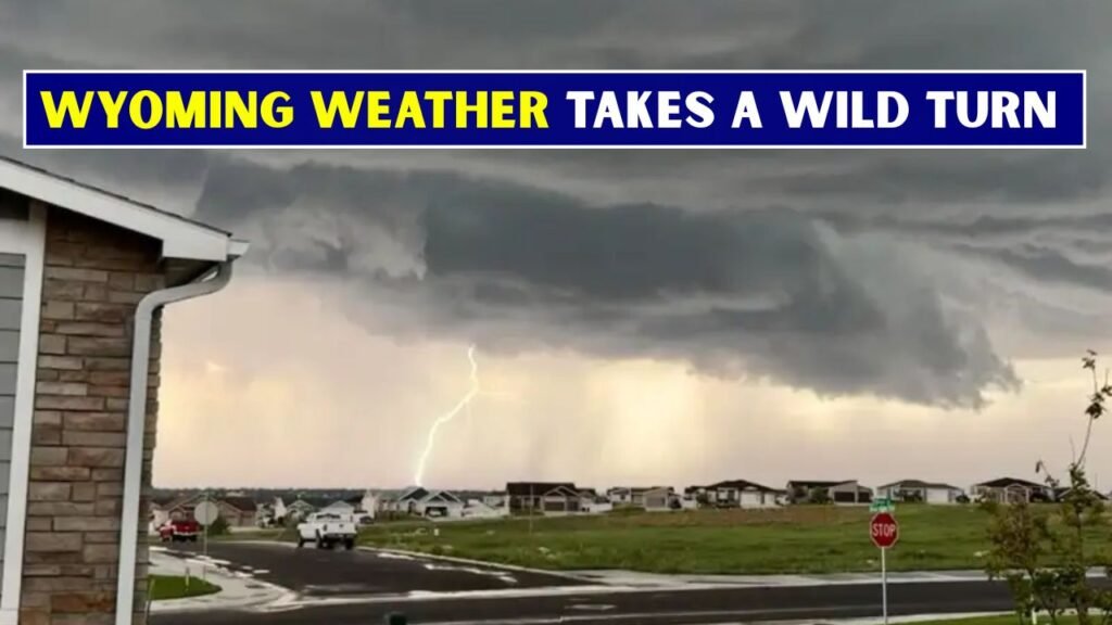
The heaviest storms might unleash more than a quick downpour. The NWS Cheyenne forecast discussion mentions large hail, severe wind and an isolated tornado as possible hazards across the eastern high plains. The initial storms may be more discrete cells, then becoming more wind-focused later in the day.

- Large hail may damage vehicles and roofs.
- Winds 30 to 40 mph with gusts up to 50 mph may damage trees and power lines.
- Heavy rain may reduce visibility for a short time.
- Lightning threat outdoors.
- An isolated tornado is not out of the question.
Which Areas Need to Stay Alert?
Communities east of the Laramie Range and out across the eastern high plains should be alert as storms develop. Cheyenne, Laramie County, Pine Bluffs, Torrington, Wheatland and surrounding rural areas: Possible changing conditions. Even sunny or calm locations shouldn’t assume the whole day will remain quiet.
What will travel be like?
Drivers along Interstate 80, Interstate 25 and local highways should be prepared for rapidly changing weather conditions. “Thunderstorms can produce brief periods of heavy rain, hail, low visibility and strong crosswinds. Storms also can generate strong outflow winds over open stretches of roadway that could make high-profile vehicles harder to control.
- Check the radar before you head out.
- Do not stop under bridges during hail
- Slow down in the heavy rain.
- Use your headlights when visibility is poor.
- Travel delays if warnings are issued.
What Should You Do Before Storms Arrive?
The best time to prep is when things are quiet. Residents should move loose items outdoors, charge phones, park vehicles under cover if possible and check out shelter options. Families should also make sure that weather alerts are turned on – storms in south-east Wyoming can rapidly intensify during afternoon and evening hours.
Will the chances of storms continue this week?
The unsettled pattern may not end anytime soon. The NWS Cheyenne says the potential for strong to severe thunderstorms in the afternoon and evening will continue Wednesday and Thursday. The NWS Cheyenne says temperatures are expected to warm above seasonal averages by the weekend, with storm chances becoming more isolated. Weather awareness is therefore needed for more than just one day for residents.
- Another storm chance possible Wednesday.
- Some isolated storms could also occur Thursday.
- Warmer weather may build towards the end of the week.
- Later, coverage of the storm may be less extensive.
Why Is Weather Awareness Important In Today’s World?
Calm weather can sometimes give you a false sense of security before thunderstorms develop. In the open country of south-east Wyoming, storms can be seen a long ways off, but they can still move fast. Local weather alerts, forecasts and radar are designed to help people make safer decisions in advance of dangerous weather.
What’s The Bottom Line?
Although South-east Wyoming could begin the day quiet, the afternoon and evening could see a change in the weather. Thunderstorms can produce hail, strong winds, lightning, and short bursts of heavy rain. Storms are on the way so take advantage of the calm start to prepare if you have outdoor plans or travel plans with livestock or property exposed to the weather.