
Strong Winds and Heavy Rain Target Southeast Coast This Week
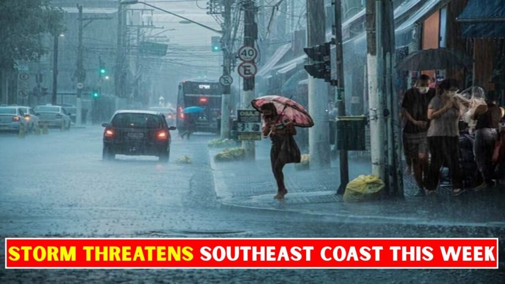
Strong Winds and Heavy Rain – A severe storm threat targets the Southeast today, stretching from the lower Jersey shore to the Carolinas. Easter egg hunts may want to happen earlier this morning or be moved indoors, as heavy rain and strong winds are set to move into the area by the afternoon, lasting through the evening and overnight hours. The main threats are heavy downpours, lightning and wind gusts as strong as 60 mph. Cities like Raleigh, Virginia Beach and Wilmington, North Carolina, will want to keep their eyes on the sky. Watch how the storm will time out.

Severe Weather Targets Southeast Coast
Weather Conditions: A stubborn, slow-moving weather pattern is funneling deep tropical moisture into the region. Widespread rainfall totals of 2 to 5 inches—with locally higher amounts in flood-prone spots—are forecast.

Winds & Hazards: Coastal regions from the Carolinas to Florida are battling gusty winds ranging between 40 and 60 mph, leading to a high risk of dangerous surf, rip currents, and minor coastal flooding.

Impacts: Flash flood watches and warnings are in effect. Localized flooding of roadways, downed power lines and airport delays are possible.

Coastal Southeast Braces for Bad Weather
Steady Rain: A series of downpours is causing isolated flooding and an ongoing threat of flash flooding in low-lying coastal areas.
Strong Winds: Gusty winds are bringing in rich tropical moisture onshore, which could cause dangerous driving conditions and minor coastal flooding.
Marine Hazards: Rough surf and hazardous marine conditions are impacting the coastline, creating an ongoing risk of rip currents
Wind and Rain Threaten Southeast
Cooler, less humid weather will filter in behind the storm, offering relief with lower temperatures and sporadic lingering showers.
Current conditions and forecast trends show a noticeable post-storm transition:
• Temperatures: Expect a 10 to 15-degree drop in highs following the storm. Conditions will feel noticeably crisper and more refreshing.
• Precipitation: The intense, severe weather will be over but leftover isolated showers may push southward into coastal areas, Alabama, Georgia and northern Florida.
• Impacts: Rainfall will be mostly beneficial in easing drought and wildfire threats in the Southeast without causing significant flooding.
Strong Winds & Heavy Rain Safety Tips
Protect your home and family from this week’s dangerous coastal weather with these 5 practical steps:
Secure Outdoor Items: High winds can turn everyday items into airborne projectiles. Tie down, tarp or bring indoors all patio furniture, garbage bins, toys and potted plants.
Clear Drains and Gutters Heavy rains: Need a clear path. Remove leaves and debris from your roof’s gutters and nearby street storm drains to avoid waterlogging and flooding.
Trim Trees and Foliage: Trim any dead, loose, or dangling branches near your roof and windows. These can easily snap off in strong winds, potentially causing serious property damage and power outages.
Secure Windows and Doors: Close storm shutters, if you have them, and lock all exterior doors and windows securely. If a severe storm or cyclone warning is issued, you may also want to tape up large windows with heavy-duty masking tape or boards to prevent them from shattering from flying debris.
Make a Plan : Power outages and flooding may isolate your neighborhood. Collect a waterproof emergency bag with non-perishable food, bottled water, essential medications, flashlights, extra batteries and copies of important documents.
Final Discussion
These weather systems conclude with a high chance of flash flooding, property destruction and power outages for coastal communities. They produce heavy, localized downpours inland, not brief showers, as they draw deep tropical moisture inland.
If this happens, the low pressure system would slow down, strengthen slightly and potentially stall closer to the coast,” the FOX Forecast Center said. “That would bring a much larger shield of rain directly along the immediate coast, alongside gusty onshore winds.”
Regardless of the exact track of this developing system, it will result in beach erosion, rough surf and minor coastal flooding across the Southeast region.